Content

Showing posts with label Tibet. Show all posts

Locations: Sera Gompa, Lhasa, Tibet, China (29� 41' 53? N, 91� 8' 0? E)
Date: 18 May 2005; 5.50pm
Camera: Canon 300D with kit lens

Any visitors to Lhasa must visit Sera Monastery, which is within Lhasa limit at the northeast corner of town. One can easily get there by public bus. There are several reasons to visit this monastery including its historical and religious significance and the size and expanse. However one good reason to visit it is to witness the daily Scripture Debate by the resident monks. The monastery had developed over the centuries as a place of scholarly learning with many famed monks in Tibetan Buddhism having trained here. Everyday around 3pm, the resident monks will gather in the garden within the compound of the monastery to debate Buddhist scriptures and philosophy. The debates are punctuated by physical gestures such as hands clapping after each question, loud screaming and verbal exchanges that tremendously enliven the ambience of the debates. Some of such gestures may seem so violent that it may appear to an uninformed observer that the monks may be having a heated argument. These debates make this monastery a special experience.

Read more »

Location: Yarlung Valley, Tibet, China (29� 8' 38.76? N, 91� 48' 0.72? E)
Date: 26 May 2005; 10.45am
Camera: Canon 300D with kit kens

The Chinese government had done it again- they closed the province of Tibet to foreigners again! The closure this time is total- not even foreigners on packaged groups are allowed to enter Tibet for a period of three months. I have bemoaned how some places in Tibet are becoming a �once a lifetime� destination due to the now frequent and arbitrary closure to foreigners. The reasons given by the Chinese government this time are ostensibly�bad weather and insufficient supply of accommodation�. Well, the weather in China had not been bad until today and there were reports from the hospitality industry in Tibet expressing puzzlement at the so-called heavy demand on accommodation. In fact the real reasons are the anniversary of the Lhasa unrest three years ago and the timing of the convening of the parliament of the Tibetan government-in-exile in India. The government was trying to avoid leakage of any scenes of demonstrations or unrests of any kind that may result due to these events. While politically I have less of a problem regarding the so-called Tibetan issue, I do have lots of reservations regarding the governance and the iron-fist treatment of minority-dominated provinces such as Tibet and Xinjiang by the Chinese government.

Read more »

Location: Ganden Gompa, Tibet, China (29� 45' 28.8? N, 91� 28' 30? )
Date: 18 August 2007, 9.30am
Camera: Canon 400D with Canon 70-200/f4L USM

Ganden Gompa is frequented by travellers to Tibet because of its proximity and easy access from Lhasa. It is situated at 4,300m and has fantastic panoramas of the Lhasa plains and valley. It also has a very interesting history to top off the view. It belongs to the Gelukpa or �Yellow Hat sect� of Tibetan Buddhism of which the Dalai Lama comes from. The monastery is one of 3 Gelukpa monasteries of Tibet. It was the original monastery of the Gelukpa order, being founded by the order�s founder, Je Tsongkhapa himself. His body was preserved and entombed in the monastery until the virtual complete destruction of the monastery by the Red Guards during the Cultural Revolution. Most of his mummified body was burnt except his skull and some ashes which were saved by the monk who was forced to carry the body to the fire. The Gandem Gompa was later re-established by the exile Tibetan population in the Tibetan settlement of Mundgod in Karnataka, India. Meanwhile the original Ganden Gompa in Tibet was reconstructed since 1980�s and more buildings are still being added today, partly due to its popularity on the tourist map. The Ganden Gompa is also one of the few remaining sacred sky burial ground in Tibet.

Technorati Tags: ,,
Read more »

Location: Chiu Gompa, Ngari, Tibet, China (30�45'55"N 81�22'5"E)
Date: 8 August 2007, 6.20am
Camera: Canon 400D with Canon 70-200/f4L USM

Ngari of Tibet is one of those destinations often described as �once-in-a lifetime� by most travel guides. Its major claim to fame is Mount Kailash, Lake Manasarovar and the Guge Valley. It is a part of China/Tibet that has been difficult for independent foreigner travellers to visit due to the proximity to the proximity to the disputed borders with India/Pakistan. A clutch of permits are needed to do so and still the chance of getting them is never assured; however a foreigner can get there relatively easier by joining a package group tour. The situation has now changed for the worst after the incidents in Lhasa and Olympics in 2008. Today it is virtually impossible to get to Ngari for an independent foreign traveller. Checkpoints had increased and the security officials are more vigilant in enforcing the rules. Hopefully China will slowly relax the restrictions again soon especially since the airport serving the region, at Gunsa, had already started operation. Otherwise this destination may indeed be a �once-in-a lifetime� destination for most non-Chinese nationals.

Read more »

Location : Tingri region, Tibet, China (28� 34' 0? N, 86� 38' 0? E)
Date : 28 April 2003; 8.25am
Camera : Canon G1
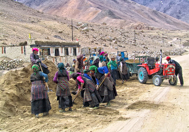
Tibet is developing so fast that it is quite mind boggling. Billions are poured into the province�s transport infrastructure with the headlining rail connection to Lhasa. Apart from that, China is building the world�s highest airport at Ngari (base to explore Mount Kailash), airport in and extension of the Lhasa rail line to Shiigatse. It is also expanding and improving the road network in the province. Few years ago the road between Lhasa and Shiigatse was a single lane bitumen road; now it is a 4-lane highway! However most of the roads in Tibet are under-utilized. It is not unusual to be on one of these roads for 20 or so minutes before encountering another vehicle. Most of the constructions connecting the major centers are undertaken with heavy machineries but some of the lesser connections are invariably still mainly built by manual labour, with little heavy machinery. This photo was the norm as far as road construction is concerned about 8 years ago- men and womenfolks using shovels- and is still the same in the smaller town connections.

Read more »

Location: Namtso, Tibet, China, (30� 42' 0? N, 90� 33' 0? E)
Date: 21 April 2003; 7.05am
Camera: Canon G1

Namtso meaning Heavenly Lake in Tibetan, is one of 3 holy lakes of Tibet; the other 2 are Manasarovar and Yamdroktso. Namtso is also the biggest lake in Tibet, the highest lake (4,718m) in the world and the 2nd largest saltwater lake in China (after Qinghai Lake) . Tibetans Buddhists believe Buddha will assemble to hold religious meeting at Namtso in the year of sheep on the Tibetan calendar. So circumambulation (kora) around the lake at the right moment equals 100 thousand times of that in normal years. Every year thousands of Buddhists from Tibetan areas in the 5th & 6th month of the Tibetan calendar, come to the lakeside on pilgrimage to pay homage and pray.

This and many other beautiful places in Tibet are now less accessible to foreigners like me. After the pro-Tibet protests prior to the 2008 Olympics, China had clamped down and strictly enforced the travel restrictions on foreigners to Tibet. These days no independent travellers can get to Tibet without going through the necessary paperwork. To travel there, one not only require a Tibet Travel Permit (TTB) as in the past, a full package have to be booked beforehand with guide and a vehicle ready (if one wants to travel outside Lhasa) when one lands in Lhasa. In other worlds, unlike in the past when one can do travel arrangements including vehicle while in Lhasa, all of these must be done before getting to Tibet. Furthermore there are more checkpoints where TTB are actually checked. I considered myself lucky to have already visited so many places and met so many people in Tibet- many of which were already off-limit to foreigners in the past.

Technorati Tags: ,,
Read more »

Location: Tingri Shekar, Tibet, China, (28� 34' 0? N, 86� 38' 0? E)
Date: 3 May 2003; 10.25am
Camera: Canon G1

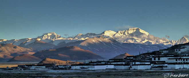
Tingri Shekar is the main though small town on the Tingri Plains, situated approximately 60 km north-west of Mount Everest and just over 50 km from the Nepali border. The Plain is approximately 4,300 meters high and the air is always crisp. Sunrise is really pretty with the thin air bringing out the glows of the dawning sun. This town is frequented by climbers and expeditions to Cho Oyu, which looms across the horizon. It is a place of raw beauty. It is also one of the driest parts of Tibet, being behind the mighty Himalayas- the monsoon clouds dumped their rain when they cool ascending the height of the Himalayas. It is also very poor with little trade crossing this way. Things have changed a little in the last few years with more tourists coming this way to the Everest Base Camp or overland to Nepal. A few of the old houses in town had been rebuilt- a sure sign that things are a-changing. It may stay this way for a couple more years as there are no public transport connecting this place to other parts of Tibet yet. But don�t hold your breath- this is China after all. So if you still want to see a beautiful landscape relatively untouched by developments and still un-swamped by tourists in China, this is it.

Read more »

Location: Chiu Gompa & Mount Kailash, Ngari, Tibet, China (30�45'55"N 81�22'5"E)
Date: 8 August 2007, 4.20am
Camera: Canon 400D with Canon 70-200/f4L USM

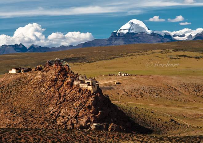
There are a few gompas surrounding Lake Manasarovar the source of the mighty Indus River (incidentally the name �India� is derived from the river). The most well-known of these gompas is Chiu Gompa which is situated in Chiu Village. It is often used by as an overnight stopover by trekkers participating in packaged trekking groups. The gompa, sitting atop a craggy hill, enjoys a fabulous vantage point overlooking the lake while Mount Kailash is visible over the distance to the north. In fact the gompa has one of the best locations in this region to view the two major reasons to visit this remote part of Tibet.

Read more »

Location : Cho Oyu from Tingri, Tibet, China (28� 34' 0? N, 86� 38' 0? E)
Date : 24 April 2003; 5.45am
Camera : Canon G1

Cho Oyu or jo bo dbu yag in Tibetan at 8,201m is the 6th highest mountain in the world. It is one of those giants that lie right at the border between Nepal and Tibet, China. Just like Everest or Qomolongma in Tibetan, expeditions to climb these mountains often start from both sides of the border. Cho Oyu is supposedly the easiest of the 8,000 metres Himalayan peaks to climb. The pass, Nangpa La, which lies a few kilometres west of the mountain used to serve as a main trading route between the Sherpas of Khumbu, Nepal and the Tibetans; and Tingri (4,300m) was a very important trading post for such traders. The Sherpas used to trade rice, grain and so on for Tibetan wool, livestock and salt. Today Tingri is still a small town of about 500 people but has a large PLA garrison/barrack at the edge of the town. No tourists will really go to Tingri unless they are on their way to the Everest Vase Camp or overland to Nepal. This will probably preserve the town's character a little longer but probably not for too long as an overland trip to the so-called Everest Base Camp (on the Chinese side ie the northeast face) is like part of any trips to Tibet.

Read more »

Location: Horse caravan on the way to Chawalong, Tibet, China ( 28� 30' 0? N, 98� 24' 0? E)
Date: 4 May 2005; 10.45am
Camera: Canon 300D with kit kens

There is a good article about the ancient Tea Horse Trail in the latest issue of the National Geographic magazine (the article has a factual error- Budweiser is never available everywhere in China. Perhaps the author is trying to make the majority of the readers, who are American feel more �at home�). The Tea Horse Trail was an ancient route used by traders to transport much needed and appreciated tea to Tibet and in return bring the famed Tibetan horses back to China. It was a series of routes, crossing over high mountain passes from Sichuan and Yunnan into (then) Tibet. It was amazing because of the hardship and amazing terrains the routes passed. The article focused on the �Middle route� which is the most difficult as it crosses some very high passes and can only be accomplished by human carrying the compressed tea bricks. Some of the other routes are no less exciting due to the deep gorges and perilous environment they passed. Though the majority of such routes are no longer in use, some are still very important as there are the only connections for people along them. An example is the Tea Horse Trail along the Nujiang Gorge (or Salween River) from Bingzhongluo in northwest Yunnan into the south of Tibet (see these articles for a description of the route/trek and an alternate entry into Tibet). The route is perilously narrow, snaking along the river and is susceptible to frequent landslides, so unsuitable for vehicles. There are many remote villages along the route and their needs for necessities such as sugar and salt (as well as beer) can only be brought in by horse caravans. The scenery along this section of the Tea Horse Trail is simply breathtaking where human and animals are simply dwarfed by the immensity and majesty of the mountains and deep gorges (see photo). This is a part of China that very few people have seen and is changing rapidly, just like the rest of the country. This photo and journey description was in mid-2005. My friend, Michael had already reported in late 2007 that a section of the route in Yunnan is now passable to 4WD�s.

Read more »

Location: Near Bayi town, Tibet, Tibet, China (29.66639�N 94.36278�E)
Date: 15 August 2007, 8.20am
Camera: Canon 400D with Sigma 17-70/f2.8-4.5

Most Tibetans are rather religious- to them living life is synonymous to living a Tibetan Buddhist life. One of the main objectives of most devoted Tibetans is a pilgrimage to sacred sites such as Potala Palace in Lhasa, Mount Kailash, Yamdroktse and so on. Their sort of pilgrimage is not just hoping on a car or bus to the destinations but to walk and prostrate all the way to the destinations. What this entail is to pray and then prostrate on all fours, laying on the ground facing the direction of the path/road for every three steps. Normally such a journey will be undertaken in a group of 2 or 3 persons. 2 pilgrims will be prostrating all the way to the destinations while a helper will pull a trolley/cart of their belongings, food, tent and camping items alongside. Such a pilgrimage journey could take many days and even months to complete, depending on where the pilgrims live in relation to their destinations. I met this young pilgrim (of a family of pilgrims) on the road near the town of Bayi. They have walked and prostrated from northern Sichuan for about 12 days, on their way to Lhasa. One can see the dark patch on his forehead, which is the result of prostrating and knocking his forehead on the ground. However, look at his expression and one will realise the inner strength and happiness he felt to be embarking on such a pilgrimage.

Read more »

Locations: Potala Palace, Lhasa, Tibet, China (29� 39' 28? N, 91� 7' 1? E)
Date: 18 May 2005; 5.50pm
Camera: Canon IXUS IZoom

Potala Palace is one of the most enigmatic and recognisable building in the world. It was the principal residence of the Dalai Lama until he fled Tibet after the Tibetan uprising. Today the Palace is a museum and is one of the most popular tourist destinations in Lhasa- it has limited the number of entrants a day and its entrance tickets are sold out every day. The hordes of tourists are apparently causing concern of stress to its structure. The palace sits atop the Potala Peak. Its surroundings used to be rather rural in nature- I remembered how rural the surroundings was when I saw the "Rainbow over Potala Palace" photo by Galen Rowell many years ago. It is now totally different. The Chinese government had spent a lot of money transforming the surrounds of the Palace into just like any other Chinese cities; including building the immense Potala Palace Square or People's Park in front of the Palace. Well, I guess that's developments in the eyes of the Chinese government.

Read more »

Locations: Prayer Flags, Ganden Monastery, Lhasa, Tibet, China (29� 45' 28.8? N, 91� 28' 30? E)
Date: 13 August 2007; 11.0am
Camera: EOS 300D with kit lens

Prayer flags are an integral part of Tibetan Buddhism. It is not found in other branches of Buddhism, hence there were speculations that it is a Bon tradition. Buddhist mantras are written on these flags and when they are blown and flutter in the wind, goodwill and compassion are delivered by the wind all over the land. Prayer flags are some of the most common sights in places that have significant Tibetan culture such as Tibet, parts of India, Nepal and Bhutan. There are commonly strung up in high places such as mountain passes as well as sacred sites such as monasteries, lakes and so on. These prayer flags are quite attractive to look at as they are normally very colourful.

Read more »

Locations: Barkhor Square, Lhasa, Tibet, China (29� 39' 11? N, 91� 7' 53? E)
Date: 11 August 2007; 8.0pm
Camera: EOS 300D with kit lens

One of the characteristics of Tibetan Buddhism is their utmost devotion to things or beings considered holy. This could be either Buddha statues, pictures of the Dalai Lama, monasteries, lakes, mountains and so on. Part of the expressions of faithful devotion is the circumambulation around such items. Devotees or pilgrims would walk a step and then bow with all fours on the floor. If it is a mountain or lake, this would be a kora- circumambulating around the object, normally over a few days depending on the size of the mountain/lake. If it is a monastery or palace such as Potala Palace, it would be several circumambulations. If it is a statue or picture, then they would pray with all fours in front it. This is one of the most commonly seen acts in front of the Jokhang Monastery in Bakhor Square, Lhasa.

Read more »

Locations: Barkhor Square, Lhasa, Tibet, China (29� 39' 11? N, 91� 7' 53? E)
Date: 19 May 2005; 6.35pm
Camera: EOS 300D with kit lens

Lhasa is a major pilgrimage destination for devout Tibetan Buddhists. Two of the sites stand out as some of the holiest in their religion- the Potala Palace and Monastery. There are virtually thousands of pilgrims and tourists from all over China visiting these places every day, for various reasons. The Tibetans will come to pray, pay respect and circumambulate at these places while tourists come to see, take photos, be amaze and so on. Barkhor Square where the Jokhang Monastery is located is one of the busiest spot in Lhasa at any day. All sorts of people mill around the square and the atmosphere is positively one of joyousness, especially among the pilgrims who have spend many years planning and relatively big amount of money to come here. Even the kids will not always remember this experience.

Read more »

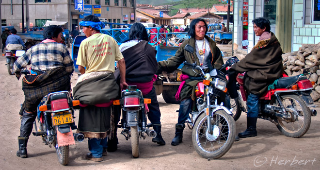
Locations: Xiahe, Gansu, China (35� 11' 50 N, 102� 30' 36 E)
Date: 26 June 2004; 5.40pm
Camera: Canon 300D with kit lens

Xiahe is a small town in present-day Gansu. It used to be part of Greater Tibet in the old days and hence, the town is still very predominantly Tibetan in every sense of the word. It is also the location of Labrang Monastery, one of the largest Tibetan Buddhist monasteries outside of the Tibet Autonomous Region. These days, the Tibetans here have substituted their choice of transport from horses while roaming in the mountains and grassland to �steel horses� i.e. the motorbikes. It is common sight to see groups of young Tibetans with their customary cigarette in their mouths on motorbikes gathering to update on the latest developments on the grasslands.

Technorati Tags: ,,
Read more »

Location: Ngari, Tibet, China (31� 4' 0? N, 81� 18' 45? E)


Date: 5 August 2007, 11.30am

Camera: Canon 400D with Sigma 17-70/f2.8-4.5

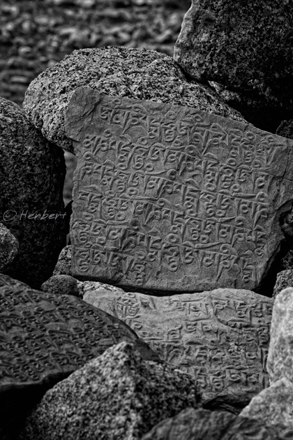
Mani stones are smooth stone plates, pebbles and rocks usually inscribed with the universal mantra �Om Mani Padme Hum� (which translate to "Hail to the jewel in the lotus"). Images of deities and sutra texts are also commonly inscribed on such stones. Sometimes there are decorated with sheep and yak horns. Mani stones are regarded as sacred, used as a sacrifice and a form of prayer in Tibetan Buddhism. Mani stones and mani stone mounds can be found almost anywhere in Tibet and Tibetan areas- in monasteries, along paths and rivers, crossings, on mountains, lakes and most prominently in high vantage points such as passes. Normally Tibetans will walk around a mani stone mound in a clockwise direction .As Tibet is sparely populated, in more remote places the mani stone mounds actually become prayer halls and shrines for local Tibetans.

Read more »

Location: Yamdrok Tso, Tibet, China, (28� 56' 0? N, 90� 41' 0? E)
Date: 23 April 2003; 10.05am
Camera: Canon G1

Yamdroktso is one of the four most sacred lakes to the Tibetans. The lake is shape like a fan and is surrounded by numerous snow peaks, including Nojin Kangtsang (7,252m) as seen here. It is one of the most beautiful lakes in Tibet with clear turquoise waters. However, the beauty of the lake is likely to be irrevocably damaged by both the building of a hydroelectric plant at the site as well as gold exploration activities in its immediate vicinity. The scarring was already visible back in 2003 with land clearing activities along its shores. I cannot imagine what damage had been done to its beauty by now.

Technorati Tags: ,
Read more »

Location: Norbulingka Palace, Lhasa, Tibet, China (29� 39' 14? N, 91� 5' 30? E)
Date: 12 August 2007, 2.20pm
Camera: Canon 400D with
Sigma 17-70/f2.8-4.5

Norbulingka was the summer palace for Tibet's Dalai Lama until "liberation" by China. Part of it is now converted into a museum and venue for traditional theatres and dances. The grounds contain fountains, pools and gardens. The gardens are popular with families especially during the Shoton Festival every August when they picnic and camp for days. The grounds are colourful during this period, adorned with makeshift windbreak of colourful rugs and Tibetans in their best and colourful costumes. Traditional operas have now become a major part of the Shoton celebration. These operas normally go on for days and can continue with a few episodes. However most, if not all of them are old stories, mainly of good against evil and some are family comedies. Nearly all of the actors/actresses wear masks during such performances.

Read more »

Location: Drigung Ti Monastery, Tibet, China, (30� 6' 23? N, 91� 12' 18? E)
Date: 23 April 2003; 12.05pm
Camera: Canon G1
Drigung Ti Monastery, about 140km from Lhasa is the mother monastery of the Drigung Kargyu lineage of the Kayupa or what is popularly known as the White Hat Sect. Kayupa is one of the four major denominations of Tibetan Buddhism (are you confused yet?).

Anyway Drigung Ti is one of the largest site for Tibetan sky burial in Tibet. In fact it was one of only two places in the whole of China where a stranger was allowed to watch (but cannot take photos or videos) a sky burial; the other site was in Langmusi, Gansu. However it seems both of these sites is now off-limit to strangers to witness the sky burials. I was lucky- I went to and witness the sky burials in both these places before 2004 when there were still accessible to strangers.

Read more »

About

Nothing happens when you sit at home. I always make it a point to carry a camera with me at all times…I just shoot at what interests me at that moment. – Elliott Erwitt"
“I treat the photograph as a work of great complexity in which you can find drama. Add to that a careful composition of landscapes, live photography, the right music and interviews with people, and it becomes a style.” – Ken Burns